
Blackaller and Head Weirs
Page updated 18th January 2016 (more on the SSSI)
These weirs are situated right next to Bonhay Road - few will not have been impressed by Blackaller Weir in full flow after heavy rain. Blackaller Weir, was also known as Calabear Weir and even Head Weir, which can cause confusion.
Blackaller Weir
Blackaller Weir originally raised the river level to feed the upper and lower leats, thus creating Exe Island
In 1568 it was noted of Blackaller Weir:
"The latter end of this year there was a severe frost, which was attended by a sudden thaw; in consequence of it great inundations were caused which did much damage, particularly to the bridges and weirs; Calabear Weir (now Head Weir) was entirely destroyed, but afterwards rebuilt in a much stronger manner."
Salmon have, for many generations, swum up the Exe to the upper reaches spawn–indeed, they still do. During the 19th Century, although salmon were often seen leaping the weir, it was feared that Blackaller Weir was blocking the salmon, so in 1863 a salmon ladder was constructed.
Head Weir
After the flood caused by the frost, a second leat and weir was built above Blackaller, in 1609 and named Head Weir. The upper leat was extended by cutting through solid rock beneath Wear Cliffe. Since then, the leat fed by Head Weir now flows under the Bonhay Road, crossing beneath Exe Street, and emerging just before the new Powhay Mills development. Blackaller Weir was then disconnected from the upper leat to solely feed Head Weir Paper Mill on the site of the Mill on the Exe public house. Later in the 19th century, Jenkins described the two weirs thus:
"... and beneath it are two strong stone weirs, which turn the river into different Head Weir, leats, on which is situated the engine that supplies the city with water, many fulling, grist, and other mills, dye-houses, &c. a great accommodation to woollen and other manufacturers; the walk between the river and leat is not above six feet in breadth, and when the river is swelled by floods is awfully grand; the great expanse of water foaming over the weirs on the left hand, the lofty cliff, clothed with wood, (which is only separated from you by the leat) on the right, and the beautiful prospect in front of the bason of the river, with the adjoining meadows, excite a sensation in strangers that cannot be described."
The photo of the boys playing on the Blackaller Weir (right) was common, although it could be dangerous. In August 1828 this was reported in the Exeter and Plymouth Gazette.
"A boy named John Pinn, who had been sent by his father to Exwick, to sell china, on Wednesday, while endeavouring to cross the head-weir, was washed off and drowned. The body was found on Thursday"
Before Bonhay Road was cut in 1863, The leat from Head weir was uncovered. There was a footbath towards Cowley between the leat and the river, with a footbridge crossing at the end. In 1830, a letter in the Gazette reported that the state of the bridge was dangerous, with gaps as wide as two feet. It was not clear who was responsible for repairs at the time. A few days later, a further reportstated that a small girl had fallen through the gap in the bridge and was swept along the leat. She was rescued, but the newspaper thought urgent repairs be made.
Site of Special Scientific Interest
The river cliff that was cut into to form the leat is now a Site of Special Scientific Interest (SSSI). The cut exposed layers that are part of the Crackington Formation that extends as far as North Devon. Each layer was formed in deep water during the Carboniferous era. It is rich in goniatites–a spiral shelled cephalopod organism. The strata which have been overturned, and are slightly tipping, consists of beds of shale and sandstone. The sandstone layers are typically 20cm in thick, with a iron nodule containing dark shales of 35cm in thickness. There are also 10cm thick layers of finely laminated siltstone.
Mill on the Exe
Head Weir Mill, was converted to a paper mill in 1798 and continued to produce paper until 1967. It was demolished in 1982 and rebuilt the next year as the Mill on the Exe public house. The new footbridge bridge just above Blackaller Weir is the innovative Millers Crossing which opened in 2002.
Sources: Local newspapers from the British Newspaper Archive and Izacke's history of Exeter.

A map from 1905 showing the position of the two weirs.

A map from 1805. Note the open leat from Head Weir to Exe Street, by Blackaller. Bonhay Road was not cut until 1863, when it culverted the leat.
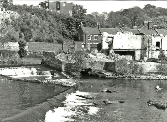
Blackaller when they were demolishing Head Weir Paper Mill.

Blackaller in flood before the mill was demolished.

Head Weir, below Mount Dinham. The cliff face is a site of Special Scientific Interest (SSI)

Boys playing on Blackaller when the water was low.
│ Top of Page │