St David's
Page updated 21st July 2011
Named after the church situated on St David's Down, the parish has been in existence from late Anglo-Saxon Times, St David's was a haven for the Saxon refugees from the city after it was taken by William I in 1068. Traditionally, the parish boundary stretched from the northern city wall to beyond the Cowley Bridge, and from the river Exe in the west to Higher Duryard in the east.
Only the occasional pack horse or traveller from North Devon travelled the main road through the parish to the Northgate. The steep Lower North Street made the journey into Exeter difficult for carts and carriages until the ironbridge was completed across the Longbrook Valley.
St David's Down, was a largely agricultural area, serving the needs of Exeter. It was in the 19th-century, that St David's became a popular place for the wealthier middle class to settle. St Clements Lane, just above St David's Station is one of the most ancient outside the city wall and once led to St Clement's Chapel, on the floodplain. The famous Lammas Fair in Exeter originated in St David's when 'bread, wine, ale and victuals' were bought and sold.
St Davids Hill was the main road until New North Road replaced it in the 19th century. The Exeter historian W G Hoskins was born in St David's Hill.
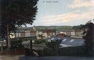
 This postcard shows the area that the Edwardians called St Davids. Central Station, then known as Queen's Street Station is in the dip.
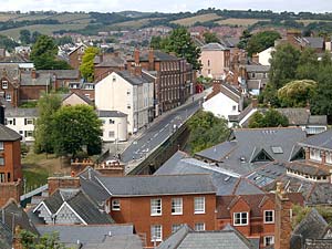
 Looking across the Iron Bridge to St David's Hill.
│ Top of Page │