
Exeter's Guildhall Centre - the 'Golden Heart Project'
Page added 1st February 2011
Back to Places in Exeter
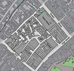 These photos show the area of the Guildhall Shopping Centre before it was redeveloped in the 1970s in what was known as the Golden Heart Project. From an area full of character, with many historic buildings, it was converted into a concrete and brick centre designed to bring in a high rent for the developer. The photos were taken by David Cornforth, Alan H Mazonowicz and the Express and Echo. A film from 1936 by Henry Holladay also supplied many stills– see Garton and King film.
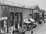
 Higher Market - then and now
The Higher MArket is the main entrance to the Guildhall Shopping Centre from Queen Street. The photo left shows a busy Queen Street when the building was still a market in the 1950s. The photo, right, shows it in 2004. ZDF, a German TV company has used the steps beneath the entrance as the Bank of England in their adaptation of some Rosamunde Pilcher novels filmed in Exeter.
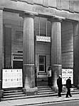 The Civic Centre - 1950s
The right hand side of the Hogher Market, where W H Smiths trades, was turned into the Civic Hall in the 1920s after the Victoria Hall burnt down in 1919. In the 1960s Pink Floyd, Led Zeppelin and Fleetwood Mac appeared on the stage. It closed in 1970.
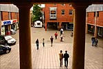 View towards the old Trickhay Street 2008
The refurbished Higher Market has an interior balcony – this is the view from the balcony towards Superdrug. Before the area was redeveloped, the view was across Goldsmith Street, which contained the Bull Inn, the Fleece, the Maltsters' Arms, the New Market Inn, the Packhorse and the Phoenix Inn at various times. Trickhay Street (right) ran parallel with Waterbeer Street towards North Street – the line of the pedestrian way in the distance is approximately where Trickhay Street was located.
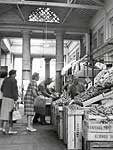
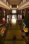 The Higher Market Hall - interior
From 1838 when it was opened, the original Higher Market housed stalls to sell fish, poultry, dairy and fruit and vegetable produce - the photo left shows a fruit and veg stall in the 1950s. When the architects designed the Guildhall Centre they were persuaded to retain the Higher Market. A through way lined with shops was installed in the old market hall, and a balcony, also lined with shops, was their solution.
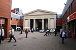
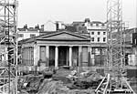 The
Higher Market facade
The magnificent facade on the rear of the Higher Market was preserved. Instead of facing Goldsmith Street it now opens onto a square which has W H Smith on one side and Tony Pryce on the other. The photo on the right shows the same scene during the redevelopment in the early 1970s.
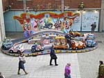 Childrens' Fairground Ride 2009
The square in front of the Higher Market is often used to promote new cars, and occasionally fairground rides for children.
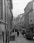
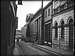 Goldsmith Street 1935
Two views of Goldsmith from the 1930s. The photo left shows the street towards the High Street with the rear of the Higher Market on the left. The photo right, from a 16mm film shows the Higher Market towards Paul Street. First named in the 13th century after the goldsmiths that worked there. Right - still from film supplied by Richard Holladay.
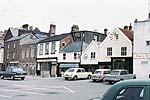 Waterbeer Street late 1960s
In the 1930s the city council compulsorily purchased many properties along Waterbeer Street, in preparation for redevelopment. The war intervened and the buildings were put to other, temporary use. After the war prior to the Golden Heart development the council owned properties were demolished. This photo shows how the area became an ad-hoc car park before the archeologists dug the area up prior to the redevelopment in the 1970s. Photo by Alan H Mazonowicz.
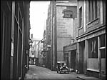 Garton and King in Waterbeer Street 1936
Garton and King was one of those businesses who moved out of Waterbeer Street after their foundry was compulsorily purchased. Henry Holladay filmed the area, including the foundry in 1936. This still shows Garton and King, looking along Waterbeer Street towards North Street. The foundry was approximately on the land now occupied by Wilkinson, formerly Woolworths. Still courtesy of Richard Holladay.
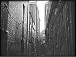 Trickhay Street 1936
Another still from the Holladay film showing Trickhay Street. The street ran parallel with Waterbeer Street along a line starting where Argos is now located – it was a dead-end at the rear of Mansfield Antiques in North Street. Still courtesy of Richard Holladay.
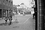
 Waterbeer Street 1979
Marks and Spencer was not constructed until after the Guildhall Centre had opened. The photo left, shows the view along the street towards the building site of Marks and Spencer in November 1979. The colour photo shows the same view today. Both photos David Cornforth.
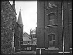
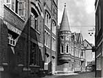 The Police Station
The City Police Station in Waterbeer Street had a distinctive round tower. These two photos show it from behind the Danish Bacon factory at the end of Trickhay Street, left, and from the front. The bacon factory became an indoor parade ground for the police after the war. Still left courtesy of Richard Holladay.
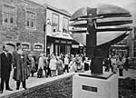
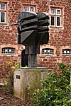 Unveiling the Looking Forward sculpture 1977
The City Council commissioned the bronze Looking Forward sculpture for the Queen's 1977 Silver Jubilee. It was cast in Woodland, near Ashburton, and weighs 1.25 tons. Mayor Roger Keast unveiled the work in September 1977. Photo left Express and Echo.
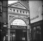
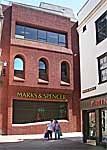 Side entrance to Waltons 1936
Walton's, Exeter's favourite department store, had a side entrance from Waterbeer Street for many years. When Marks and Spencer had their store built on the corner of Queen Street they proposed that they would preserve the facade of the old Walton's side entrance. In the event, they forgot their pledge and we ended up with the brick construction right. Left, composite photo from Richard Holladay's film.
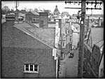 Waterbeer Street from the roof of Garton and King 1936
Henry Holladay filmed a panoramic view from the roof of Garton and King. This still shows the view down Waterbeer Street towards Goldsmith Street. Courtesy of Richard Holladay.
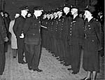 A police parade in the Bacon Factory 1954
Phyllis Wooldridge was the city police force's first female PC, when she joined the force in 1949, with the number PW1. Here she is pictured at the front of a line of police officers on parade in the old bacon factory, in Waterbeer Street. They are undergoing the annual inspection by HMI Ian St Johnstone in 1954.
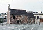 St Pancras Church - early 1970s
This small church was first recorded in 1191, although the font is all that remains from that period. The majority of the surviving church dates from the 13th century, with some 16th century windows and a wagon roof. There was a small graveyard associated with the church. Before the Golden Heart redevelopment the area around the church was used for car parking. Photo courtesy of Alan H Mazonowicz.
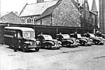 Police vehicles by St Pancras Church - early 1950s
A row of police cars parked behind St Pancras Church in the 1950s.
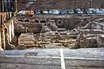 Archeological excavation of Garton and King - 1970s
This large hole is the site of Garton and King. North Street is in the background. The original foundry was destroyed by fire in 1826 – the insurance paid for a new foundry on the former site of the Episcopal School. Photo courtesy of Alan H Mazonowicz.
 Archeological excavation 1970s
A car park and then Paul Street and beyond, the City Wall can be seen on the other side of the excavations in this photo. Photo courtesy of Alan H Mazonowicz.
 Archeological excavations 1970s
More archeological excavations in the Golden Heart development. Photo courtesy of Alan H Mazonowicz.
 Archeological excavations 1970s
This paling has been well preserved beneath the old buildings behind the Guildhall and High Market. Photo courtesy of Alan H Mazonowicz.