
Bonhay Road
Updated 30th May 2018
 This name may come from
the Norman French for 'goodhay'. However, 'hay'
also means enclosed by a hedge. A 1687 map shows the area named
'Bonehayer', while a 1744 map has it named 'Bunney'. Bonhay stretches
from the Exe Bridge
as far as Blackaller Weir, just above the present day Mill on the
Exe and includes all the land between the river and the now filled in,
Lower Leat. It was a pleasant tree lined area that was used by locals
for
taking a walk. Later, much of the river bank was given over to rack
fields, before Exe Island was industrialised, and the cattle market
located near the bridge. Bonhay Road runs beside the old line of the
Lower Leat from the
Exe Bridge to the Mill on the Exe, and on to St David's Station.
This name may come from
the Norman French for 'goodhay'. However, 'hay'
also means enclosed by a hedge. A 1687 map shows the area named
'Bonehayer', while a 1744 map has it named 'Bunney'. Bonhay stretches
from the Exe Bridge
as far as Blackaller Weir, just above the present day Mill on the
Exe and includes all the land between the river and the now filled in,
Lower Leat. It was a pleasant tree lined area that was used by locals
for
taking a walk. Later, much of the river bank was given over to rack
fields, before Exe Island was industrialised, and the cattle market
located near the bridge. Bonhay Road runs beside the old line of the
Lower Leat from the
Exe Bridge to the Mill on the Exe, and on to St David's Station.
The Bonhay Fair was revived after a 30 year lapse, in August 1819.
"Wrestling and cudgel playing are forbidden by authority; but various other elegant amusements, such as Ladies running for gowns, shawls, and a chemise, men jumping in sacks, a pig race, &c. are to take place."
Four years later and menageries, shows, and booth's that once appeared at Dix's Field, were also removed to the Bonhay. This probably accounts for the two lion cubs that were born in the Bonhay in 1838, one of which, was christened Exonia by the Mayor, W J P Wilkinson.
A fly and horse, also in 1838, driven by a man named Ayshford accidentally turned right from Exe Street at Engine Bridge, towards Head Weir. There was no road from Engine Bridge in this direction at this time. Realising his error, he tried to turn the horse and fly, when the wheels went into the leat, dragging the driver and horse after it. A call went out to the Humane Society's Reception House and several men turned out to rescue the man. Meanwhile the fly, horse and driver had been swept down the leat and were caught under the wheel of the Water Engine. The wheel was fortunately stopped, so the rescuers ripped up the planks over the leat and pulled the driver to safety. The horse could not be saved and "lived for two hours, uttering the most piteous moans. The fly was smashed almost to pieces". (Times)
Industry and pollution
The area become more industrial, with the opening of the Exeter Gas Light & Coke Company in 1815/17 on Exe Island. A report in 1869 noted that the smell from the 'Gas Ammonical Liquor Distillery and Manure Factory' was considered to be a public health danger in the Bonhay.
It was in the 1830's when the Lower and Higher Markets were built in the city, that the cattle market was moved down to Bonhay, on the banks of the Exe. There was also a slaughter house further along the Bonhay Road, and in times of flood, animal blood would often bubble up through the drains. During the Second World War, Bonhay Park was used as a scrap iron dumping ground. The cattle market was closed and moved out to Marsh Barton in 1939.
Bonhay Road opens
On Wednesday 15 April 1863, the section of road between Head Weir mill and St David's station was opened. At 11 am a procession of civic dignitaries and a wagon, drawn by seven horses, laden with porters and decorated with flags traversed the new section for the first time. The length of Bonhay Road between the Exe Bridge and the Head Weir mill, which had been known as Prince's Road for many years was renamed Bonhay Road along with the new section. Prior to the extension, only a track for pedestrians linked the station with Prince's Road–there was a small wooden bridge from the end of the 'spit' between the leat and river, and the track. The new section was paid for by the Great Western Railway, who funded the upkeep of the road for the first year, before it was taken over by the council.
Leisure facilities
The movement to provide parks and pleasure grounds for the populace in the late 19th century led to the opening of the Bonhay Pleasure Ground, on the Exe bank, adjacent to the cattle market. Here, a scrap of open green park was provided for the enjoyment of the residents of Exe Island. At first, the police stationed an officer in the police house in the Pleasure Ground, but later a full time warden occupied the lodge. Between Bonhay Road and the river, next to the London and South Western railway line was the Head Weir bathing ground, the domain of Frank Shooter.
There were three pubs in Bonhay Road, all of which have closed. The Cattle Market Inn, and the Shakespeare Inn were back to back on the Lower Leat. They were both popular with workers and farmers at the cattle market, and both were closed in 1968 for the roads works associated with building the Northern Exe bridge crossing. The Lazy Landlord, formerly the Princess Alexandra closed in 2002, was demolished and replaced by apartments. Dating from the mid 19th century, it was used, in 1879, to lay out the body of Reginald Hide, a six month old child whose body was found dismembered in the leat of Powhay Mill. Annie Tooke was found guilty of his murder and hanged at Exeter prison.
World War One Dead - Bonhay Road
Corporal, Headley Tollick, Devonshire Regiment. 7 October 1917. Age 25. Rose Mary Cottages, Bonhay Road
Bonhay's SSSI
Further along Bonhay Road is a length of exposed river cliff that is a Site of Special Scientific Interest (SSSI). It is part of the Crackington Formation, a Carboniferous layer of twisted sandstones and mudstones, about 320 millions years old that stretches from Crackington on the Bristol Channel across Devon to Germany. This river cliff, although it has been cut back for Bonhay Road, uncovers deep water deposits of sandstone, siltstone and shale layers that are dipping and are faulted in places. Fossils associated with that period can be found in the rock.
Mr Parfitt, the librarian at the Devon and Exeter Institution, was an amateur scientist. In 1873 he investigated a vein of quicksilver, said to exist at Head Weir; he concluded that the quicksilver had been placed there or had arrived by accident.
Sources: Victorian Exeter by Robert Newton, the Flying Post and James Cossins.
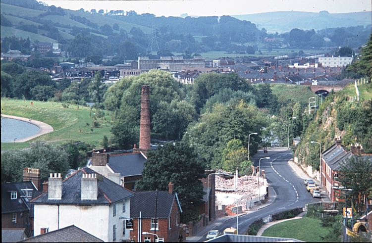
Bonhay Road looking towards the Head Weir Mill and the SSSI. Photo by Dick Passmore.
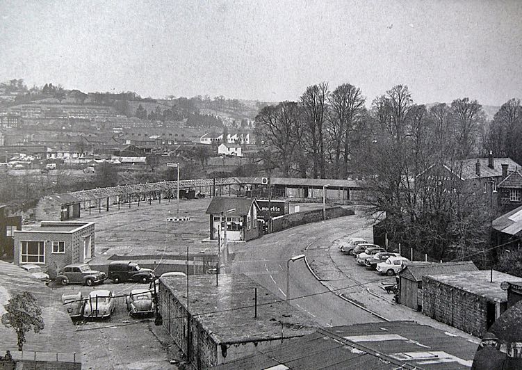
The cattle market, probably about 1950. It closed in 1939, and was used for storing scrap iron for the war effort.
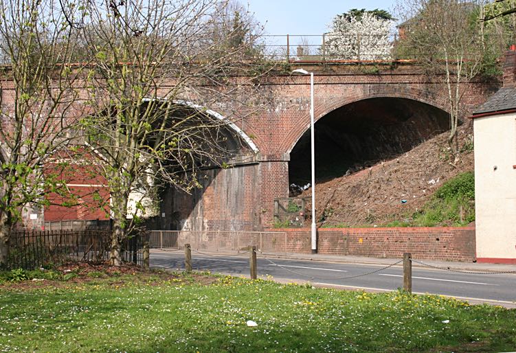
The railway bridge was built in 1861, and the line to St David's Station opened on 1 February 1862.
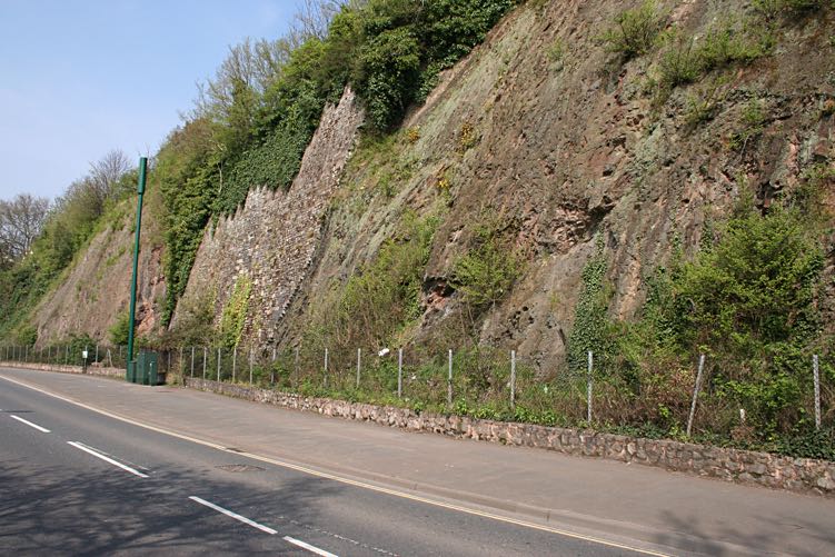
The river cliff is the Bonhay SSSI.

The Princess Alexandra pub was one of three in Bonhay Road.

The leat emerged from beneath the river cliff at Water Engine Bridge.
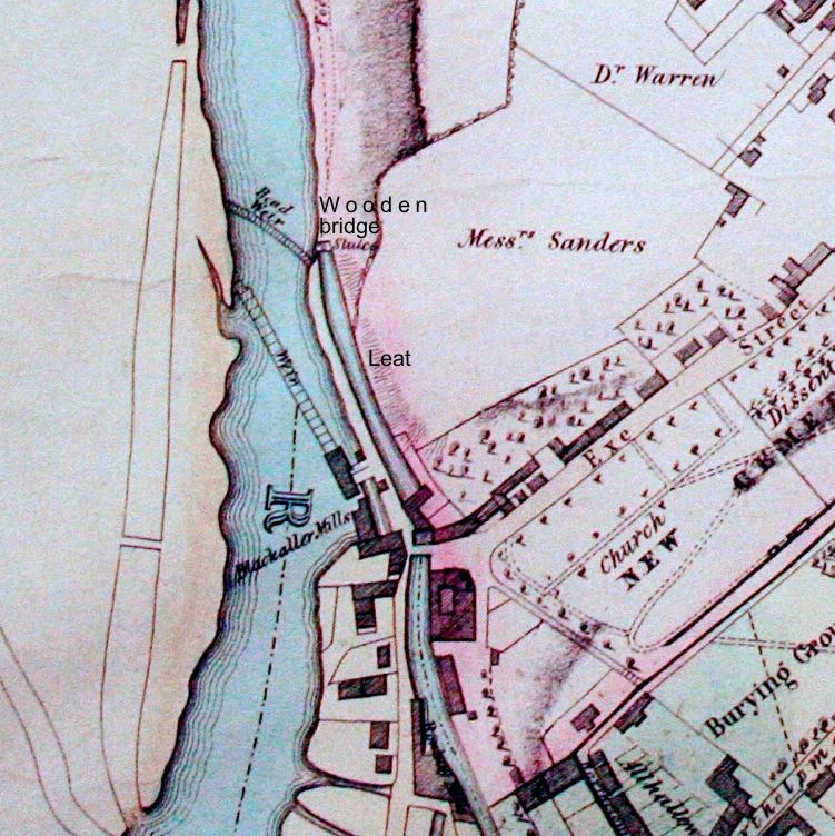
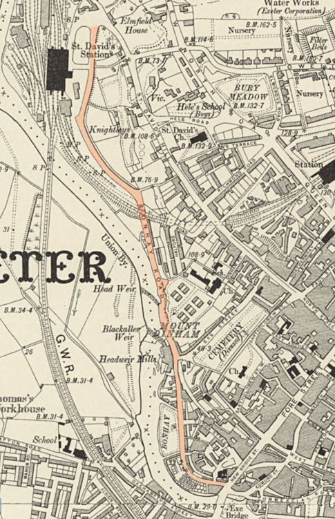
The map shows how the leat, beneath the river cliff and now under Bonhay Road, was open until about 1862.
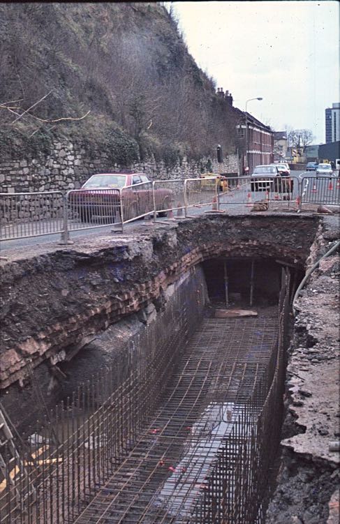
The leat was exposed for strengthening in the 1970s.
│ Top of Page │