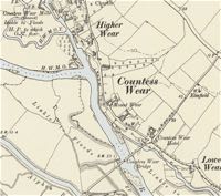
Countess Wear
Page updated 23rd March 2015
 The village like parish of
Countess Wear was
originally a part of a greater Topsham, which in itself, was a part of
the St Thomas Union. The village had gained some importance when it
became the subject of a disputed weir in the thirteenth century, and as
such, became the cockpit in the disputes between Topsham and the City
of Exeter. Although the church of St Luke's had been built in 1837-8 at
a cost of £900, it was not until the 14th September 1844 that it
became a parish
in its own right. The church was extended in 1895
for £1,200.
The area was named after Isabella de Fortibus, the Countess of Devon, who in the time of Henry III, built the weir to power her mills - or so the story goes. There are several discrepancies in the story of the first weir, and it may have been constructed before 1272 with a thirty foot gap in the middle to allow vessels to pass, or it was built in 1284 as a solid structure and reopened in 1290. What is known is that the salmon fishery at Exeter was damaged, causing friction between her successor, and cousin, Hugh Courtenay and the city. Hooker states that Hugh Courtenay deliberately blocked the gap with tree trunks between 1317 and 1327, and in effect, cut the port of Exeter off from the sea and enabled Topsham to steal the maritime trade of the Port of Exeter.
For more than 250 years the dispute dragged on, with the city petitioning the King to have the waterway reopened. In 1550, Edward VI granted permission for the weir to be breached, but it was too late; the river channel had silted up. Building the Exeter Ship Canal commenced in 1564 and opened in Autumn 1566, by John Trew. This was England's first canal with pound locks. Its original entrance was at Countess Wear, before the canal was extended further down the Exe estuary, initially in 1676 to Topsham, and to Turf Locks in 1827, to allow larger ships to enter.
Countess Wear Bridge
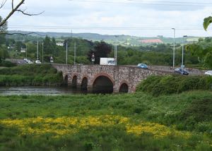
The road and Countess Wear bridge across the Exe bisects Countess Wear, with the main village to the north and the Glasshouse estate to the south. An Act for the road "... from Bear's Hill Oak Corner, in the Exminster Road, to the Red Post in the Topsham Road and building a bridge at the Ford at Countess Wear" was obtained and on 1st June 1769, the first planning meeting took place at the Salutation Inn, Topsham. The bridge was built of limestone at the lowest fording place of the river and opened on 14th September 1774. Despite the toll of 1 shilling for a coach and six horses, 10 pence for a score of oxen and a penny per person, it would not be until October 1874 that the last creditor would be finally paid off.
The swing bridge across the canal has been a known feature of Countess Wear from at least 1821, when James Green extended the canal, and probably from when the canal was extended to Topsham in 1676. The present swing bridge dates from 1936 while the parallel bascule bridge is from 1972.
The Topsham Road which forms the traditional north-eastern boundary of the parish dates back to Roman times. It was an important route for pack horses and carts both before the canal, and during the canal's working life. The road was first macadamed in 1819 when a contract was signed between the Turnpike Trust and Mr J L McAdam. Where the Wonford stream crosses the road at Northbrook was bridged in 1839/40.
Wear Park
Originally, the greater part of Countess Wear was occupied by Weir Park, which had been known in the time of Henry III as Heneaton, and then Hineton or Honiton Seige. The estate had belonged at first to the Bukenton family, then the Bathonias, Medsteads and last, John Holland the nephew of Sir Thomas Holland. It passed to the Foulkes and was purchased in 1760, from the Rodds of Cornwall, by the Exeter merchants, the Spicers.
The Spicers sold the estate in 1804, to admiral Sir Thomas Duckworth (d 1817) who rebuilt Wear House, the main residence. Captain Sir George Henry James Duckworth-King was the last Duckworth to be listed at the house in 1919, and by 1923 Ernest Charles Eveleigh was in residence.
It was put up for sale in 1927 and in 1929 the house and remainder of the estate was sold to the Exeter Golf and Country Club. When the Americans entered the war, and preparations were being made for D-day, the house and half of the golf course were occupied by the US Navy Supply Depot, the largest such facility in the south of England. After the war, the house and part of the land were returned to the golf club, while a large swathe was retained for use by an MOD Naval Store.
The Glasshouse
Glass making was established at a site in the south of Countess Wear in 1681. A glass cone almost a hundred feet high was constructed for the production of bottles for the wine trade. By 1691, William Rennel, his son, Jos. Marshall, John Hopping, Richard Hele and John Ridler were listed working the glasshouse, while the owner was Richard Renell in 1701. A print from 1798 indicates, there were in total, three glass cones.
Glass making may have continued until 1793, but records are very sketchy. Of course, the lasting heritage of the factory is the name of Glasshouse Lane and Glasshouse Cottage. See Glass House Factory for a longer history.
In 1746 the site of the glass-house was taken over for housing French prisoners-of-war. Documents indicate that a Collector of Customs named Crew was directed by the Admiralty to adapt a house at the glasshouse to take the prisoners. In late 1746, 1,000 prisoners were held by Crew, but not all in the house as it was not complete.
In 1684, a sugar-house was also built further down the river, with hogshead of sugar unloaded by crane from lighters. Samuel Buttall, the owner of a slave plantation in South Carolina, opened the factory and later took his sons, Benjamin and John into partnership. His brother, Charles Buttall also supplied the factory from his slave plantation in Barbados. Samuel Buttall died in 1723 and his son-in-law, Sir Nathaniel Hodges took a half share in the business during 1725. In 1744, Sir Nathaniel's wife, Lady Hodges sold the works as instructed by his will.
The sugar-house was demolished and Retreat House built on the site at the end of the 18th century.
The Paper Mill
In the nineteenth century, paper making was well established at Countess Wear; the earliest reference to a mill on St James' Weir leat was in 1563 when John Trew considered the leat as a possible route for the canal, an idea abandoned, partly because of the expense of compensating the mill owner. The leat had been in existence since the establishing by the Cluniac Priory on the land of Isca College of Media Arts, of a grist mill. The use of the site as a paper mill dates from before 1750. The paper mill was destroyed by fire twice, and two of the owners committed suicide during the nineteenth century.
In 1842, Thomas Whitaker merged two of the arches of Countess Wear bridge for Robert Davy, allowing his barges of coal access to the paper mill. The paper mill continued production until 1885 when it closed and the site was dismantled. In 1899 the remaining buildings were purchased by Mr W Percy Sladen. A water driven generator was installed for a time to provide power to the mill house and other buildings, while the City Council considered the site for a new sewage farm before they constructed one at Belle Isle. Now, the remains of the buildings on the leat and the still occupied mill house and cottages can be viewed from Mill Drive.
Shipbuilding and Lime burning
Robert Davy was also involved in shipbuilding at Gulpit, between the bridge and Glasshouse. The Glasshouse yard was established around about 1792, and the two yards in total registered 13 ships up to 1812. He built ships for the East India Service, the West India trade and navy frigates, as well as the Batavia of 600 tons. Both his yards closed in 1820.
To supply both his ship building and lime burning businesses, up to a 1,000 barges per year would bring in timber from the Baltic, coal from Wales and limestone from Babbacombe and Berryhead. In 1855, his son employed 10 lighters to import 7,000 tons of coal and 10,000 tons of limestone. However, the river was prone to silting, and often the barges had to be hauled upstream by man power. By the end of the nineteenth-century the trade was gone. Of the three limekilns in Countess Wear, two were below the bridge, while the last one to close in 1914, was situated in the village, leaving just Limekiln Lane as a memory of more industrious times. There was a stone on the last limekiln that was marked Richard Greenslade 1728.
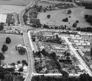
Before the expansion of Exeter into its suburbs, Countess Wear was largely an agricultural area, growing wheat, barley and root vegetables with, as already acknowledged, some industrial activity along the margins of the Exe estuary. The council estate of Glasshouse Lane and Lower Wear Road was constructed from 1951despite residents of Topsham Road appealing against the build, because it would affect house values.
The family of Chris Martin of Coldplay originated in Countess Wear, with his grandfather John Martin becoming Mayor of Exeter in 1968. The family acquired a fortune from the sale of Martins Caravans and farmland in Countess Wear.
The parish became part of Exeter in 1966 when Topsham was absorbed into the city boundary. Now Countess Wear is in the political area of Priory, which contains much of Wonford including Burnthouse Lane. Although Exeter has grown and encroached on all its rural neighbours during the last two hundred years, the village of Countess Wear has not changed so much as some other parts of the city. It is still very much a village between Topsham and the city.
Sources: The Story of Countess Weir by L E Bartlett (1915), The Ports of the Exe Estuary 1660-1860 - E A G Clark, French Prisoners of War by S Bhanji (Transactions of the Devonshire Association), Exeter City Council and various County Directories, Aileen Fox’s article on The Retreat in Devon Archaeological Society Proceedings and wills of the Hodges family.
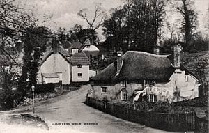
 A nostalgic view of Countess Wear.
Limekiln Lane.
 Countess Wear bridge.
 The Glasshouse Lane Estate was constructed in 1951/3.
Pubs of Countess Wear
Tally Ho - originally named
the Globe Inn, it became the Oddfellows Inn before 1894 and the
Tally Ho before 1956.
Premier Travel Inn - The
first record of this inn's existence was a To Let notice in 1818 as the
Countess Wear Inn, when it was much closer to the river, near the
bridge. Eight graves were discovered at the inn in 1850 which are
possibly those of French prisoners-of-war from the Glasshouse camp close by.
Relocated circa 1935 to its present site, when the A379 was
improved to take traffic around Exeter. Also known as the Exeter Moat
House and Countess Wear Hotel.
Country House Inn - First
listed in 1816, this public house was situated on the edge of Countess
Wear on the Topsham Road, opposite Northbrook Park. This public house
closed in January 2008.
│ Top of Page │