
- Home
- Memories
- Scrapbook ▽
- Topics ▽
- People ▽
- Events
- Photos
- Site Map
- Timeline
The parish of St Leonards has become in the last hundred years, one of the most desired addresses in the city. It has not always been so - for hundreds of years, St Leonards, insulated from the ancient city of Exeter, by the Sutbrooke Valley (also known by the Anglo Saxon Shytebrook for obvious reasons) along which flowed the now culverted Larkbeare Stream, was small, sparsely populated and mostly poor, with the exception of one or two estates..
The original scrap of St Leonard's covered a mere 173 acres, and was the smallest parish in Devon. It had a roughly C shaped spread across a flat plain between the Sutbrook and Northbrook valleys. It was enlarged in 1869 when land by Fairpark Road was added to the parish. Since then, the interior of the C has been filled in, adding all the land to the west of Barrack Road, while part of the old city parish of St Trinity, that lay outside the South Gate, including much of Magdalen Street and Holloway Street, was added in 1969. The modern St Leonard's has two city councillors for the population of 4,500 people.
There has been just a single discovery of a Roman coin dating to Emperor Galienus (260AD), to indicate that the Romans were in the area. They barely touched the land south of the city, apart from driving the Topsham Road through to their port six miles south, and Magdalen Street towards the east.
There is no mention of the land of St Leonard's in Domesday, so the early life of the parish is most reliably traced through the history of St Leonard's Church. It is thought that the first reference to a church, was one built by Richard de Redvers, the 1st Earl of Devon in 1107. In 1140 Stephen of St Leonard gave six acres of land to the Cluniac monks to form a priory at St James by Salmon Pool. It is from this priory, that closed before the Reformation, that the old Priory School took its name. The de Redvers would evolve into the Courtenays, who had so much influence on the history of Exeter and the lands along the Exe Valley.
In 1159 a deed for the church was witnessed by one Reginaldo de Sancto Leonaro, and in 1200 there was a mention in the will of Peter de Palermo, when he bequeathed 28d (pennies) for the upkeep of the parish.
St Leonards was small and detached from Exeter, and yet the murder of Walter Lechlade in the Cathedral Yard in 1283 led to Master Lucas the rector of St Leonards to be implicated in the dastardly act - clearly the dispute between the Chamber and the Cathedral affected the small parish.
From 1348, the Courtenays held sway over the parish, as the Earl of Devon appointed all the rectors until 1556, apart from three who were appointed by the reigning monarch. The churchyard became the home of Alice the Hermit, when the bishop gave permission for her to reside there in 1397, and the favour was extended to Christine Hobley (Holtby), a canoness who was made homeless when the Augustine Priory of Kildare was destroyed by the Irish, some 50 years later.
The building of Countess Wear by Isabella de Fortibus, and the complete blocking of the river by Hugh de Courtenay, after he had been granted the manor of Topsham in 1300, increased the number of pack horses, carts and trucker mucks passing along the Topsham Road between the Port of Topsham and the city. This traffic would wax and wane, after the canal was built in 1563, according to its state of repair.
Although small, with an impoverished living for the incumbent rector, St Leonard's did support one important house in late mediaeval times - Larkbeare House part of which still stands on the corner of Roberts Road. The earliest reference was in 1253 when Walter de Okestone granted Segar de Clist a garden without the Southgate in Carterne-street, by the brook next to Richard de Leverbere's (Larkebeare) land, and which of course, is still in existence. The brook of course was the Larkbeare, which even then, was culverted where it flowed through the Larkbeare House's estate to hide the stench.
In 1556, at the demise of the Courtenay's, the patronage of the church passed to the Hull family from Larkbeare, who had a new church built.
A later inhabitant, from 1737, of Larkbeare House was John Baring, whose sons went on to found the infamous Barings Bank, brought down by Nick Leeson in 1995. As the family became wealthy, initially from the woollen trade and then banking, the eldest son John became lord of the manor of Heavitree and thus, owner of Mount Radford House in 1755. The house was originally built by Lawrence Radford during the reign of Elizabeth I. It became named Mount Radford House during the Civil War when the Royalist defenders of the city set up the house as one of a string of outer forts to keep the New Model Army of General Fairfax at bay. It was eventually surrendered to Parliament at the treaty of Poltimore in April 1646.
However, it was the acquisition of the property that saw it turned into a grand Georgian manor house by John Baring MP.
As Holloway Street climbed into the Topsham Road, it passed within 40 ft of the old Mount Radford House. In 1779, Baring had the road moved towards the church and a cutting made to ease the hill for horse drawn traffic - an arched footbridge put in place to link Mount Radford with the church was still in place in the 1920's. Eventually, the house lent its name to a whole area of Mount Radford House.
The Baring family were originally Lutherans, and helped account for some of the dissenters in St Leonard's, which the rector noted in 1744. Of 17 families in the parish, 12 were Church of England while the rest were Presbyterian, Baptist and Quaker.
St Leonards Road was originally cut as the entrance drive for Mount Radford House. Upon John Baring's death in 1816, the estate was sold to Messr. Hooper and other speculative builders, who set about transforming St Leonards into a gracious suburb for retiring military men and civil servants from India. The house became a school, only to be demolished in 1902 to make way for Barnardo Road.Baring Crescent was an early development built by Hoopers on Baring land 'as a place of residence for people of independent means'. (Exeter Gazette)
A meeting at the Congdon's Hotel (Royal Clarence Hotel) on 6th April 1826 established a deaf and dumb institute for Devon and Cornwall. After opening in St Thomas, a new building was erected in St Leonards in 1828, on 2 acres of land between the Topsham Road and the river. The original building was extended in 1862.
Exeter was busy modernising in the early 19th Century and these innovations quickly reach St Leonard's with piped water in 1833 and gas in 1836, both no doubt hastened by Hooper's building boom. Excluding Trinity Parish, there were no public houses in the parish. Within Trinity, the Windmill Inn, in Holloway Street, close to Bull Meadow Road was the closest, while the Port Royal on St Leonard's Quay was handy for those who wanted to rent a rowing boat for a trip on the river.
For those who lived in the corner of St Leonard's at Larkbeare, down by the river, things were not nearly so pleasant. On the site of a former fulling mill that existed in 1633, a cotton mill was opened by Robert Tripping at Trews Weir in 1793, that employed 300, but it was not a success and closed in 1812. John Heathcote, who went on to establish a machine lace mill in Tiverton, briefly considered the empty site for his business. It then became tenements, before it reopened as a paper mill in 1834, to provide an important centre for employment, right through to the 1980's when it was run by John Pitt and Sons. However, Exeter did not prosper after the 1850's when low wages and unemployment brought soup kitchens to many. In 1870, those in employment at the paper mill could at least look forward to being treated to dinner at the Port Royal by their employers.
Nearby was the so called, Match Factory, although it never manufactured a single match. The building displays the date 1774; it was the Lower Mill flax mill in the 1850's, and later was used by John Pitt and Sons for making paper bags and the storage of materials. It became known as the Match Factory, after an owner, who was fond of collecting old artifacts, acquired a Match Factory sign, which he hung from the building. That modern rebirth for an old building, as residential apartments has since been applied to the Match Factory.
Locals also worked the lime kilns behind the Port Royal using lime from Babbacombe and coal from Newcastle, which was landed on St Leonards Quay by barge. Records show that the kilns were in existence in 1726, worked by Hole and Stabback, while in 1850, they are listed to W H & W W Hooper. The kilns were in the grounds of the other Larkbeare House, a greystone Victorian pile, that occupied some former rack fields. The house was purchased by the city in 1876 and is now used as a judges residence and a centre for hosting conventions. Between 1878 and 1882 the house was the temporary premises of Maynard's School, as they awaited the completion of their High School for Girls in Spicer Road.
In 1801 the population of St Leonard's was 133, while by 1851 it had grown to 1,499, fuelled by the incoming middle classes; growth after 1850 slowed as Exeter's building boom declined along with a depression in farming and agricultural prices, upon which the city had become dependent.
The growth in the first part of the century increased the size of the congregation in St Leonard's Church and it became obvious that the old building was no longer large enough, requiring it to be rebuilt in 1833. The new building was unfortunately a bit of a gerry built affair, with a flat iron roof that had a tendency to leak, and in 1876, a foundation stone for a new church was laid by the Earl of Northbrook; ten years later the 145 ft spire was added.
And then for the parishioners of St Leonard's, much against their will, disaster struck when in 1877 the parish was absorbed by Exeter.
In 1902 the Exeter Building Estates Company started developing Mount Radford House and the St Leonard's estates - by June 1904 the grounds were built upon and the house partly demolished to be replaced with 200 houses at £14 year rent including Barnardo Road. Other large houses were built in St Leonard's during the 19th Century, and it was into one of these, Bellair, that Lady Georgina Buller, daughter of the erstwhile General, lived in the first half of the twentieth century. Georgina Buller did much charitable work in Exeter, and helped develop both St Loyes College and the Princess Elizabeth Orthopaedic Hospital, for which she helped raise £21,000 in 1927.
St Leonard's did not see the same intensity of bomb damage, that others parts of the city suffered during the blitz of April and May 1942. However, St Leonards Road did lose some houses from direct hits, that were replaced after the war, and Parkerswell House was also destroyed by a bomb.
In the twentieth century, St Leonards for the most part, remained a genteel suburb, although the area around Holloway and Magdalen Street saw many changes in the 1960s and 70s. Western Way was cut through the West Quarter, requiring the demolition of many properties in Magdalen and Holloway Street including the Valiant Soldier and Acorn pubs.
A major centre of employment in the modern St Leonard's is County Hall, the headquarters of Devon County Council. The old houses of Coaver and Bellair came into possession of the County Council, forming the nucleas of the new County Hall, built in 1958. Coaver is a social and conference centre, while Bellair is an annexe to the Council Chambers. Ironically, for Exeter, St Leonards has been designated a Conservation Area to preserve the many historic buildings and trees that are part of the suburb. The area is also a centre for language schools and retirement homes, uses for which the many Victorian villas are admirably suited.
Source: St Leonard's by Robert Dymond, Eight Hundred Years of St Leonard's by A E Roach, trade directories, St Leonard's by Gilbert Venn, Victorian Exeter by Robert Newton, Jenkins History of Exeter plus other diverse sources. © 2007 David Cornforth - not to be used without permission.
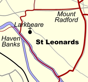 St Leonard's - the modern ward.
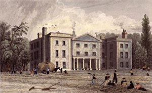 Mount Radford House when it was a school.
St Leonard's trivia
Population growth
1801 133
1841 1,129
1851 1,499
2005 4,504
• Households 2,175 (2005)
Councillors 2006
• Norman Shiel - Conservative
• John Winterbottom - Conservative
• Tommy Cooper went to school
in St Leonard's Road.
• Past St Leonards Residents
• Sir John Bowring, 4th governor of Hong Kong
• Juliet Morris, TV presenter
• John Dymond JP, historian of 1 St Leonards Road.
• Dominic Wood of Dick and Dom in Da Bungalow.
• W G Hoskins, broadcaster and historian.
• Lady Georgina Buller, daughter of General Buller of Downes, Crediton.
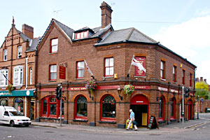 Mount Radford Inn
Streets and areas of St Leonard's
Larkbeare
Mount Radford
Magdalen Street & Road - Trinity
St Leonards Road - Mt Radord
Holloway Street - Larkbeare
Baring Crescent - Mt Radford
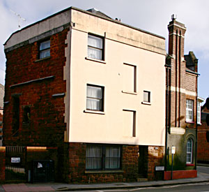 Larkbeare House in Holloway Street
Some pubs of St Leonard's
Mount Radford Inn - Magdalen Road
Windmill Inn - Holloway Street
Hour Glass Inn - Friernhay
Port Royal Inn
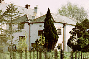 The Match factory complete with sign.
│ Top of Page │